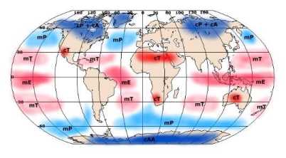
 Continental tropical air mass forms over deserts in the southwestern United States. These types of air masses bring dry, hot, humid weather throughout the summer, they don't form during winter. Maritime tropical air mass forms over the warm water in the tropical Atlantic Ocean. This brings mild, usually cloudy weather to the eastern United States during the winter. |
 Polar air masses form over ice and snow covered land. These masses of air move within the northern United States and occasionally have the ability to reach as far south as the Gulf Coast of the United States. During the summer, the air masses usually bring cool, dry weather. In the winter time, they bring very cold weather to the northern United States. Maritime polar air masses form over the North Pacific Ocean and are extremely damp, but not as cold as continental polar air masses. |
|
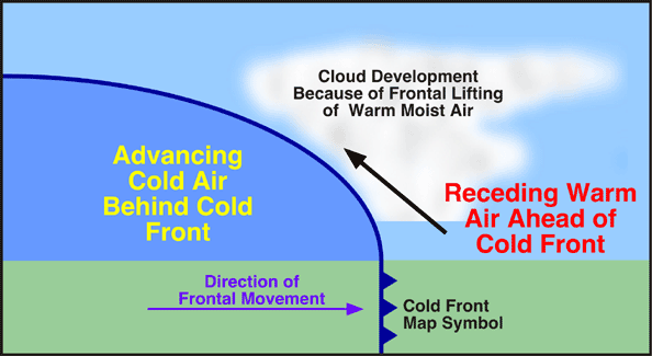
There are three types of fronts, cold, warm, and stationary air fronts. Cold fronts form when a cold air mass overtakes a warm air mass. The cold air that is moving lifts the warm air, if this warm air is moist, clouds form. Common clouds that form as a result of this type of front are large cumulus and cumulonimbus clouds. These fronts usually form storms that are short-lived but sometimes very violent. A long line of heavy thunderstorms may transpire in the warm, damp air just ahead of a fast-moving cold front. Warm fronts form when a cold air mass departs from a specific area. The lighter warm air rises over the cooler air. The slope of a warm front is gradual, with that, clouds are able to aggrandize far ahead of the base of the front. Warm fronts usually create precipitation over large areas and may even cause violent weather. A stationary front occurs when air masses move either very slowly or not at all. The weather caused by this type of front is similar to that caused by a warm front. 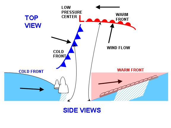 |
||